
Historical Markers
Joseph L. Casbeer
A Confederate veteran. Born in Lamar County. In Civil War, was in Co. G, Col. R. T. P. Allen's Texas Infantry, and was discharged in 1865. On September 5, 1871, married Miss Matilda Peacock, in Lampasas County. They had 2 sons. Moved to Ozona in 1898. Recorded - 1970.First Water Well
Ave. D at First Baptist Church, was drilled in 1891 and became focus for early life in Ozona.Focus for civic life in early Ozona. City founder E. M. Powell provided the water well equipped with 18-foot windmill, a water trough, and a small cypress tank. At first meeting of Crockett County Commissioners Court, July 22, 1891, under a live-oak near the well, the sheriff was instructed to operate the city water works. At the time, tents housed most homes and stores, and water was hauled from city well--often by children using toy wagons. In a few years homes had private wells and windmills. A modern system piped water throughout the city in the early 1900s.
Water System, Water Works Drive
fed by a well dug for E. M. Powell who laid out town and donated water well, storage cistern, windmill and land for public buildings.This site was selected for the Crockett County seat in 1891 because of a producing water well (200' northwest). Joe Moss, who drilled for water throughout the area, dug the well for E. M. Powell (1847-1925), railroad surveyor, financier, and land developer. Powell laid out the town, donated the water well, windmill, storage cistern, and land for public buildings. Immediately the Commissioners Court designated the well site as County property. Residents hauled water home by hand, on horseback, and by wagon. Later a wagon delivered barrels of water door-to-door. As a result of Ozona's rapid growth by 1900, Judge Charles E. Davidson organized locally-owned "Ozona Improvement Company." The business drilled more wells and laid a pipeline in town. This hilltop, a familiar site of windmills and sprawling storage tanks, was called "Waterworks Hill." In a few years power equipment was added to provide electricity and ice. A municipal water district was formed in the late 1930s under the guidance of Joe North. Ozona's has not suffered from a decrease in its water supply during times of drought. Its water system utilizes the vast underground limestone formations in which moisture is stored.
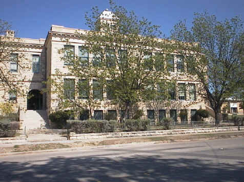
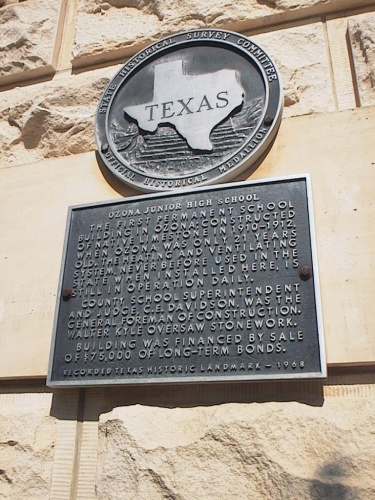
Ozona Junior High School
Heritage Building (school), Ave E., Ozona Junior High School - Ozona, corner of 6th and Avenue E (SH 163) OzonaThe first permanent school building in Ozona; constructed of native limestone in 1910-1912, when Ozona was only 21 years old. The heating and ventilating system, never before used in the state when installed here, is still in operation daily. County school superintendent and judge, C. E. Davidson, was the general foreman of construction. Walter Kyle oversaw stonework. Building was financed by sale of $75,000 of long-term bonds. Recorded Texas Historic Landmark, 1968
Photos donated by Clayton Hooper
Old Ozona National Bank Building
Ave. E, the county's first financial institution, was constructed in 1905 of native stone.Constructed 1905 for county's first financial institution. Organized by cattle and sheep ranchers and the town's doctor. During construction of native stone building, banking was done next door in store of L. B. Cox, vice-president. J. W. Henderson was president. Directors were Dr. A. W. Clayton, S. E. Couch, Wm. P. Hoover, Robert Massie and J. B. Moore. J. B. Reilly was cashier. The second floor is owned by the Masonic Lodge. RTHL - 1966
The Perner House
Ave D., moved to the present site from Emerald in 1893.In 1893, T. L. Hammonds moved a 3-room frame house from the nearby town of Emerald to this site. In 1894, Phillip Perner (1860-1905), a local merchant, purchased and enlarged the structure. Following Perner's death, his wife, Mary Ross Perner (1864-1942), and their 11 children continued to live here. The house was sold in 1944 to Ralph Jones (1905-72), who was later elected a Crockett County Commissioner and County Judge. Mrs. Ralph Jones is current (1975) owner. Recorded Texas Historic Landmark--1975
The Emerald House
fair ground park between IH-10 and U.S. 290, moved to Ozona from Emerald townsite.Although the early history of this structure is unrecorded, it is known that the house originally was built in the townsite of Emerald (9 miles east). Established in 1889 as Crockett County's first settlement, Emerald was the colonization project of railroad agent T. A. Wilkinson. When Crockett County was organized formally in 1891, an election was held to determine the site of the county seat. Emerald lost its bid for the seat of government to a newly developing area that became the town of Ozona. Within a few years, many of Emerald's buildings, including this house, were moved to the new county seat. As a result, Emerald eventually disappeared. Until 1981, when it was moved to this site, the Emerald house was located on one of Ozona's Main Streets. It had been owned by many of the town's prominent citizens, including E. M. Powell, an early area surveyor who gave the land for many of the town's public buildings and parks; pioneer merchant Phil Perner; newspaper publisher W. A. Cochran; ranchers George L. Harrell and J. W. Friend, and E. B. Deland. As one of Crockett County's earliest structures and a survivor of its first settlement, the Emerald House is a significant reminder of the County's heritage.
Hoover, Laura and William Peery
Hoover Divide, from Ozona take I-10 west to US 290, go southwest about 4 miles to CR 406, go south about 16 miles to Marker (at intersection with CR 409) (marker is on CR 406)Although Indians, Spaniards, wagon trains, and military expeditions crossed through this area earlier, the first permanent settlers in present-day Crockett County were native Texans Laura (McNutt) (1862-1941) and William Peery Hoover (1854-1922), who settled here in 1881. Traveling by way of the Devils River and Beaver Lake, they migrated to this area with two children and 200 head of longhorn cattle. Their first home, constructed of cedar pickets, was located under a bluff overlooking the Pecos River. The Hoovers had fourteen children, five of whom died in infancy. Isolated, the family had to be self-sufficient, since supply trips to the nearest towns, over 75 miles away, took several days. Laura and William Hoover steadily acquired land and their holdings grew to over 100,000 acres. Their cattle were identified by the "Hoo" brand. The Hoovers later moved to present-day Ozona (50 miles northeast) and became active in the development of the community. William was instrumental in the formation of Crockett County and helped organize the Ozona National Bank. 100 years after the Hoovers settled in this area, much of their land is still owned by descendants.
Pharis Hurst
U.S. Army veteran of Civil War, discharged after loss of arm, siege of Vicksburg. Born in Pennsylvania. Came to Texas after war. Was a farmer-teacher-postmaster. Wives: (1) Melinde Beal; (2) Zilla Parker. Had 4 children. Lived in Ozona 1917-1927. Recorded-1970Samuel Theodore Smith
A Confederate veteran, of 18th La. Cav. Bn., Civil War. Born in Louisiana. Came to Texas in 1872; to Ozona, 1891. Built city's first school, first courthouse, Baptist church, other structures. Married Alice Crimm, March 1, 1876. Had three children. Recorded-1970Old Government Road
Lancaster Hill roadside park 30.5 miles west of Ozona on U.S. 290, linked Army posts between Fort Clark and Fort Stockton.Route of march and troop supply on Texas frontier. Followed in part pre-Columbian Indian trails and "Old Chihuahua Trail" that ran from San Antonio to El Paso and Mexico. In 1840s this was extended to Gulf Coast Port of Indianola where imported goods arrived from the United States and Europe, and were freighted out to be exchanged in Chihuahua for ore of silver and gold, leather goods, and other products. In 1848 water holes and camp sites were marked as this road was re-charted for use of U.S. troops sent to protect Texas frontiers from Indian invasions. Army posts were built along this road: Fort Clark, between San Antonio and Del Rio, 1852; Fort Davis, in the Davis Mountains, 1854; Camp Lancaster, at this site, became Fort Lancaster in 1856. Camp Hudson and Fort Stockton were founded in 1857 and 1859. With all the army traffic, trail won new name of "Government Road." Pioneer settlers, adventurers, California-bound gold seekers--even camel trains in government service--traveled this road in spite of frequent encounters with Comanches, Apaches, Kiowas, and other Indians. The Army finally stationed troops in continuous picket line from San Antonio to El Paso. However, it was not until 1870 that relatively safe passage was assured.
First Producing Oil Well
junction of SH 137 and U.S. 190, 22 miles northwest of Ozona, came in at a depth of 2,647 feet in 1925.In 1923 World Oil Co., owned by Chester R. Bunker, Ft. Worth publisher and printer, began drilling on the L. P. Powell Ranch. Work progressed slowly, depending on the availability of money, under the direction of superintendent Mickey Green and the tool pusher known only as "Dangerous Dan." The wildcat operation proved successful in the spring of 1925, when the first well (10 mi. northwest) came in at a depth of 2647 feet and began producing 25 barrels of oil a day. The strike opened up the world pool, more commonly known as the Powell Field, which is still yielding oil. Eventually 180 wells were drilled by a number of companies on Powell's 9260-acre ranch. Bunker, a New York-born World War I veteran, sold his rights to Humble and Marland Oil Co. after the strike, but Powell's heirs still own the land. Powell No. 1 has produced continuously since 1925 and now, under the operation of Petro-Lewis, yields 10 barrels a day. Powell No. 1 was the beginning of a vital new industry for Crockett County, before 1925 primarily a ranching area. The next important strike occurred in the Crockett Field in 1938. There are currently over 2000 producing oil and gas wells in the county.
High Lonesome Stage Stand
roadside park 9 miles north of Ozona on SH 163,First station after leaving Ozona on the San Angelo-Ozona mail line. Here, at the 20-mile point of an 86-mile run, fresh horses awaited. The stand, built in 1902, served one of Texas' last commercial stage lines. Ten horses were kept here, as at the three other stations: Shoeingstand (where the horses were reshod each six weeks), Sherwood, and Knickerbocker. Frequent riders were whiskey drummers (peddlers), lightning rod salesmen and preachers. Automobiles (1908) and finally the railroad (1910) put the "hacks" on this line out of business.
Parker Ranch Home
County Road 310 2 1/2 miles from Iraan, is a Spanish Colonial Home built in 1929 by Mr. and Mrs. O. W. Parker.O. W. Parker (1876-1962) moved to Crockett County in 1902 and worked for local ranchers until he eventually established his own ranch. Parker had this house built for his family after the 1926 Yates oil field discovery brought prosperity to the region. Completed in 1930, it is a fine example of Spanish Colonial Revival architecture. The property was also known for its orchards and gardens, tended by O. W.'s wife, Mildred (d. 1970). Recorded Texas Historic Landmark-1994
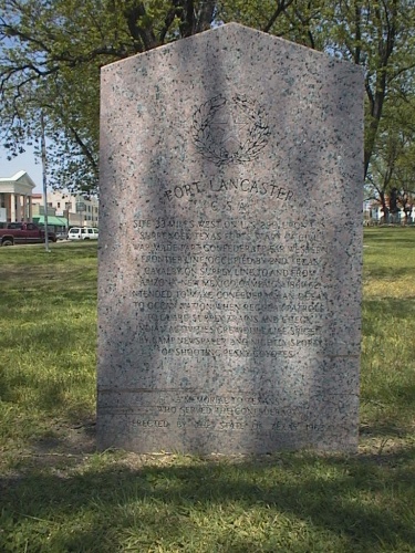
Fort Lancaster
Fort Lancaster, U.S. 290, 36 miles west of Ozona, established in 1855 to protect travelers on the Old Government Road.Recorded Texas Historic Landmark - 1966.
First Commissioners' Court Meeting
Ave. D, convened under the large oak tree on July 22, 1891. Plaque located at the base of tree at First Baptist Parsonage.Crockett County Jail
Ave. D east of CourthouseBuilt 1892, about a year after county's organization; contractor was Z. D. Gafford of San Angelo. Building stone was quarried to north of structure, on Meyers property. Tower may have been designed for hangings, but no gallows were ever installed. Though never filled to capacity, inmates have included the 1954 robbers of Ozona National Bank. In sheriff's quarters, Ozona children about 1915 took piano lessons from sheriff's wife. Recorded Texas Historic Landmark, 1966.
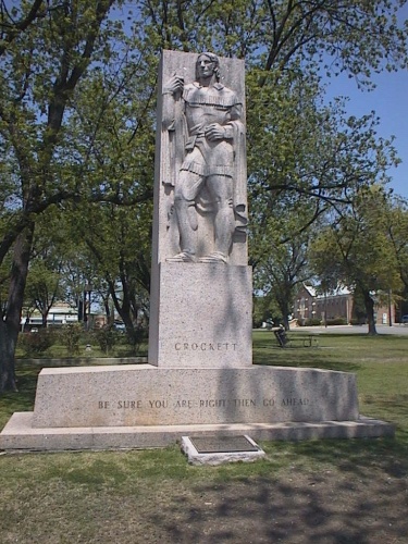
David Crockett Statue
11th Street on town square, honors Alamo hero.Was born in Tennessee on August 17, 1786 Participated in the Creek Indian Campaign 1813-1814 Member of the Tennessee House of Representatives 1821-1823. United States Congressman from Tennessee 1827-1831 and 1833-1835 Arrived in Texas in January 1836 Died a hero at the Alamo March the Sixth 1836. "Be sure you are right - then go ahead."
Photo Donated by Clayton Hooper
Old Ozona Hotel
(now Preddy Funeral Home), 10th Street, built in 1893 to board teachers, visiting athletic teams and business visitors to the city.Built about 1893. From its early days, boarded teachers, visiting athletic teams and business callers in city. Noted guests of 1919-1921 were geologists and lease men seeking to develop the now-significant oil fields of Crockett County. Recorded Texas Historic Landmark, 1968
The Ozona Stockman
Ave E., weekly newspaper has provided continuous coverage since 1892.In 1892 Claude B. Hudspeth (1877-1941) began publication of a weekly newspaper called the "Ozona Kicker." Following his three-year ownership, Hudspeth entered politics, serving first in the Texas Legislature and later as representative from the Sixteenth Texas District to the United States Congress. The newspaper was published by later owners as the "Enterprise," "Courier," and "Optimist." When County Judge Charles E. Davidson purchased the operation in 1913, he changed the name to "Ozona Stockman" to reflect the important role of cattlemen and the ranching industry in the development of Crockett County and the surrounding area. W. Evart White took over as publisher and editor in 1926. A native of Tom Green County, he had served on newspaper staffs in Austin, San Angelo, San Antonio, and Cuero before purchasing the "Stockman." Under his leadership the content and format of the paper were changed to match the style of leading daily publications. In 1941 White directed the work on an 88-page special edition. Printed in honor of Crockett County's 50th anniversary, it was considered a major achievement for the staff of a weekly paper. White retired in 1972 after 46 years with the "Stockman."
Powell, Ernest Malapert
Ozona, not yet placed, not sure of final locationA native of Illinois, E. M. Powell was a surveyor and railroad engineer in Kentucky before moving to Texas in 1874. He worked as a surveyor during the railroad construction boom in Texas in the 1870s, taking parcels of land in payment for his services. By 1878 Powell and a partner, E. L. Gage, opened a real estate and land surveying company in Dallas. Powell soon began promoting his land holdings in West Texas and placed newspaper advertisements to encourage settlement in this area. To the first families who purchased homesteads out of his 185,000-acre tract of land in present Crockett County, he offered forty acres of free land as well as reduced prices for additional acreage. The city of Ozona was founded on Powell's property. He provided a public well and windmill, as well as lots for public buildings, churches, and a school. As a result of his settlement efforts, the county of Crockett was organized in 1891 with Ozona as the county seat. Married to the former Mary Almyra Durrell, Powell was the father of one son, Durrell, who died at age seven. Powell was a major contributor to the Dallas Congregational Church and to other charities.
Emerald Townsite
Ozona, from Ozona, take IH-10 6 miles east, exit 372 (Taylor Box Rd) go north to Circle Box Motel (on I-10), marker is on brick wall in front of Circle Bar SteakhouseThe first platted town in Crockett County, Emerald was founded in 1889 by Fort Worth & Rio Grande Railway Immigration Agent T. W. Wilkinson. It was to be an agricultural shipping point on a planned extension of the F.W. & R.G. Publicized from Maine to Minnesota for mild climate and fertile land, it acquired a post office on April 8, 1890. Mail came from San Angelo via Knickerbocker (50 miles northeast). Charles Hatch and E. C. Moore were successive postmasters. In August 1890 the town was in the path of a prairie fire. Although valiant work turned the fire, it was visible for two nights before and two nights after it circled the town. Also in 1890, the county's first school session was held in a tent in Emerald by Mrs. John Noyes. After a frame schoolhouse was built, Mrs. John Ketchpaw taught there. Miss Ada Williams taught the last school term in the spring of 1893. Confident it would be the county seat, Emerald nevertheless lost in the election of 1891 to the E. M. Powell water well site (now Ozona). Wilkinson protested, to no avail. After the residents began to move to the Powell Well, Emerald Post Office closed on December 7, 1891. The townsite thus became one of the many colonization failures in West Texas.
Henry Street Hudspeth
A Confederate veteran. Captain, Co. B. 2nd Regiment, Arkansas Cavalry, Civil War. Born in Mississippi. Came to Texas, 1877. Served as county clerk after moving here, 1888. Married Elizabeth A. Royal. One of his 5 children was U.S. Congressman C. B. Hudspeth. Recorded-1970
William Mathias Miller
Born in Maryland. Fought in Civil War as a Virginian in the Confederate Army, although he had brothers in the U.S. Army. He came to Texas soon after the war. Married Henrietta Norrid in Fredericksburg, August 23, 1870. Lived in Ozona in old age. Recorded - 1970The Chihuahua Trail and Escondido Water Hole
marker located at Fort Lancaster, 36 miles west of Ozona on U.S. 290, touched all known water holes in the area. Escondido Water Hole saved lives of many travelers.The Chihuahua Trail was opened by segments, but was not called by this name until the 19th century. A small part of the route, along the nearby Pecos River, was followed by the Spaniard Gaspar Castano de Sosa in 1590, during an expedition to New Mexico. By 1850, the trail was finally extended to connect the city of Chihuahua and the Texas Gulf Coast, by way of San Antonio. Gold seekers going to California found it practical because it touched at all known water holes in this rugged terrain. Heaviest use of the trail came during the mid-1870s, when freighters transported tons of silver and copper from the state of Chihuahua for shipment to the eastern U.S. One of the landmarks along the Chihuahua Trail in this part of western Texas was Escondido ("Hidden") water hole, seven miles southeast of Fort Lancaster. A small, deep well in the side of a rugged canyon, this water source was very hard to find, but saved the lives of many travelers. However, it is flanked by rock cairns marking the graves of some who died near the water hole of accidents or disease.
Fort Lancaster, C.S.A.
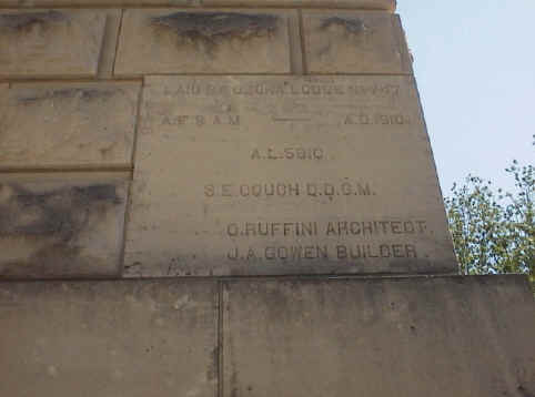
town square, 11th Street, erected as memorial to Texans who served in Confederacy at Fort Lancaster.Site 33 miles west on US 90. Upon US surrender Texas Forts start of Civil War, made part Confederate far western frontier line. Occupied by 2nd Texas cavalry. On supply line to and from Arizona-New Mexico Campaign 1861-62, intended to make Confederacy an ocean to ocean nation. When regular patrols to guard supply trains and check Indian activities grew dull, life spiced by camp newspaper and nightly sport of shooting pesky coyotes. A memorial to Texans who served the Confederacy Erected by the State of Texas 1963
Photo Donated by Clayton Hooper
Ozona-Barnhart Trap Company
SH right of way 7 miles north of Ozona.By the 1920s many ranchers in Crockett County had fenced their land, preventing their neighbors from driving sheep and cattle to the railroad shipping point in Barnhart (23 miles north of here). A solution to the problem was offered by the Ozona-Barnhart Trap Co., which was organized in Ozona in 1924. By buying or leasing land for trails, traps (small pastures), pens, and water wells, the company established a corridor through which ranchers could drive their livestock to the railroad without crossing their neighbor's fences or destroying his grass supply. The main trail extended about 34 miles, from south of Ozona to Barnhart, with branch lines throughout the county. The McNutt traps (2 miles northwest), with 1340 acres of pasture, were the hub of the trail. Sale of stock to area ranchmen financed the enterprise, and operating expenses were handled by a charge per head of livestock for services used. The O. - B. Trap Co. saved the ranching industry at a time when it was the only important business in Crockett County. The need for the trail dwindled with the rise of truck transportation in the 1930s, but drives were still held until the 1950s. The O. - B. Trap Co. now leases its land for grazing or gas production.
Comstock-Ozona Stage Stand
SH 163, 20 miles south of Ozona, was the first stop on a passenger and mail line connecting Ozona with the Southern Pacific railhead at Comstock 80 miles away.Flagstone ruins nearby mark site of early 1900's stage stand, first stop on passenger and mail line connecting Ozona with Southern Pacific railhead at Comstock--80 miles distant. When stage pulled in about 8:30 A.M. (having left Ozona at 5:00) agent had fresh horses in harness for next 20-mile run. Agent's family lived in tent with a flagstone floor. Other structures here were rock pens for a pig and cow and probably a corral for horses. Automobile replaced stage about 1914, but wagon ruts are still visible.
Crockett County Museum
Ozona. General, History, Non-Historic Structure, Museum Building Type: Historic Structure Natural History, Archeology, Historical, Local/Pioneer History, ArchivesHoward's Well
marker placed at Fort Lancaster, 36 miles west of Ozona, was landmark of western travel.First known to civilized men in the 18th century, when, according to legend, Franciscan Padre Alvarez prayed for water to ease his thirst, put down his staff, and saw a spring gush forth from the ground. This landmark of western travel was named for its rediscoverer, Richard A. Howard of San Antonio, an ex-Texas Ranger. Howard and other men, along with 15 Delaware Indian guides, made up an expedition sent out in 1848 under Col. John Coffee Hays to map a wagon road from San Antonio to El Paso. Although aided by the discovery of the well, the expedition failed, turning back in a state of near-starvation. In 1849 the US Army made its maps of the route, with Howard along as a guide. Many forty-niners went this way to the California gold rush. In 1853 the first regular San Antonio to El Paso mail line was routed by way of the well. So were many later ventures. Although white travelers seldom caught sight of them, Indians frequented the well. There on April 20, 1872, Comanches and Kiowas surprised a large wagon train led by a man named Gonzales, and killed 16 persons. This was one of the events that led to the US Government's cancellation of hunting permits for reservation Indians.
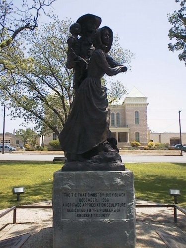
Memorial to the Pioneers of Crockett County
This is "The Tie That Binds", by Judy Black, the Memorial to the Pioneers of Crockett County located in the Ozona town square.Photo Donated by Clayton Hooper