
Tarrant County TXGenWeb
Tannahill Cemetery
Contributed by Tom Plank
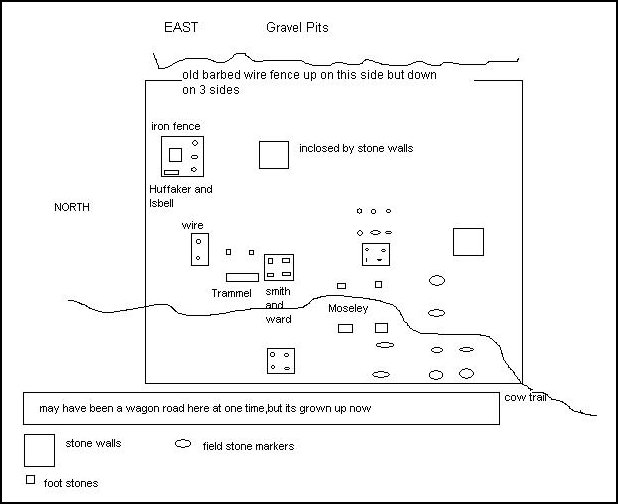
Approximately 1.04 miles down Silver Creek Rd., off Confederate Park Rd., at the first left bend in the road, there used to be an old dairy. West of there are woods and hills, where there is an old cemetery with many unmarked graves, identified only by field stones. You can clearly see the markings of the head and foot stones laid out for them undisturbed for over a hundred years, except for the cattle allowed to roam the area. Evidence of the original barbed wire surrounding it is still there, even though it has been down for many years. Cattle luckily has not destroyed any of the granite monuments marking the few graves with names. There are 4 separate areas enclosed with field stone stacked 12ft x 10ft x 4ft high, looks like each only holding 2 graves each. The area is grown up very densely with oak and briars.
I failed to get digital photos on this visit as my batteries were dead, even though I had charged them days before. Upset was not the word to describe how I felt when I was ready to use it. So with a pad and pen I tried to do my best to layout the area and record the names, but only a photo or first hand sight of some of the most beautiful and large monuments could justly describe them. It must have been very difficult to carry and locate them there. But because of the extreme floods to the area sometimes, they had to be on high ground or be swept away. They could have had a wagon road there then, but all evidence of it is lost now, as it is very heavily grown up.
Once there, you can see why they chose the area. It at present, is just due west of the gravel pits, which is a shear drop of about 200-300 ft, at the fence line. I did not dare cross the eastward fence, which the graves are about 100ft from the edge. I would say the old fence lines are about 150ft x 150ft square, just a guess by walking it off.
Many of the enclosed areas all seem to be about 30 feet apart east to west and 15-20 feet apart north to south, with many field stone marked graves near by. My sorry drawing no matter how well I try to do it, comes close to how it really is laid out, as I had no tape measure. The area up and down Silver Creek is being developed with very expensive homes on the hill sides. Let's hope no one destroys this sacred ground,which few may know exist.
Buried there are:
George Isbell
b. Jan. 7, 1823
d. Feb. 14, 1881
The largest monument 3 x 3 base and a round taper, 7 foot high
inside a 15 x 15 x 4 foot heavy iron fence, with the following.
Princie daughter of
W.H. & Alice Huffaker
b. Apr. 1, 1880
d. Nov. 20, 1882
3 other field stones depicting 2 more graves
-------------------------------------------------------------
West of them and a little south approximately 30ft:
2 field stones enclosed with heavy wire fence 3 x 5 x 4 foot depicting 1 grave like a child
-------------------------------------------------------------
West and south of it about 15 feet:
Double head stone and foot markers of approximately 4 feet high by 3 feet wide.
W. J. Trammel
b. Dec. 10, 1844
[no death date]
WJT
Dora Trammel
b. Apr. 21, 1854
d. Aug. 6, 1889
DT
-------------------------------------------------------------
Next to them inside approximately a 10 x 12 x 4 foot field stone enclosure:
Amanda B. Smith
b. June 20, 1861
d. Aug. 28, 1878
ABS [foot marker]
There is a plaque on the ground with the reading:
"To Angle form thy spirits grown for his own"
James Ward
b. Aug. 10, 1813
d. Oct. 21, 1878
-------------------------------------------------------------
Due west of them is another field stone same size but not as high, on one layer of stone in ground.
4 field stones inside depicting 2 graves.
-------------------------------------------------------------
South of it are 2 monuments about 3 x 3 x 5 feet high of:
Amanda J.Moseley
wife of Henry
b. Apr. 24, 1829
d. Aug. 13, 1878
AJM [at foot]
Henry
b. Oct. 15, 1825
d. Apr. 16, 1890
HM [at foot]
Click for Moseley headstone photographs.
Cattle trail runs between the head and foot stones:
-------------------------------------------------------------
West behind Henry are 2 field stones for a grave:
To his west about maybe 30 feet or so near the corner of the fence line are 6 more field stones clearly laid out as markers for 3 more graves:
Back to the east of there you can see another 10 x 10 x 3 foot enclosure. And to its north, another with 4 field stones in it. And north behind it you can see 6 more field stones laid 3 north to south with the foot stones east of them. It is very clear there a 3 separate graves. All the stones seem too be in the ground pretty deep, not just lying loose.
And last, about 30 feet east and north of them is another enclosure 10 x 10 x 3 foot, which would put it about 30 feet or so south from the George Isbell iron fence. I did not really see any stones in it, because it was full of leaves.
One enclosure west had 5 trees growing out of it. There could be more field stone markers I did not see.
-------------------------------------------------------------
In total, I found about 18 field stone graves and 8 marked graves. Maybe one day someone with chain saws will clean this up and put a fence back up for protection. Cattle had already knocked down one wall, no doubt to get to the green grass growing there. I do plan to return one day before development or the gravel pit swallows it up and get digital photos.
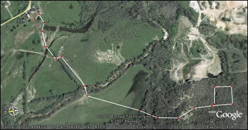
Remember this is high on a hill top west of Silver Creek Road and above the gravel pits, about a mile from the road and through dense woods. Enter the woods north of the pits and then go south, up the hill. It's not too hard a hike if you can stick to the cow trails. The best time to go would be while its dry as there are a lot of low places that would be flooded out after a heavy rain. You must cross one creek with water at a low crossing next to the iron bridge and then another that would be dry farther inside, before heading up hill to the south.
Special thanks to Bobby Garrett for finding this again. His grand parents
used to run the dairy back in the 50's.
![]()
![]()
![]()
![]()
![]()
This page was last modified 11 July 2007.
Copyright © Tarrant County TXGenWeb 2007. All rights reserved