
WELCOME TO
MITCHELL COUNTY, TEXAS
The TXGenWeb
Project and The USGenWeb Project

|
|
WELCOME TO
|
|
If you have loved ones interned here and they are not listed or do not have markers,
please contact me by email: -Mitchell County Coordinator
Photos by Becky Hudgins
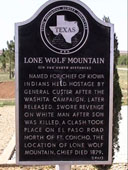 Historical Marker: Lone Wolf Mountain, (In the north distance). Named for chief of Kiowa
Indians held hostage by General Custer after the Washita Campaign. Later
released, swore revenge on white man after son was killed. A clash took place on
El Paso Road, North of Ft. Concho. The location of Lone Wolf Mountain. Chief
died 1879. (1967)
Historical Marker: Lone Wolf Mountain, (In the north distance). Named for chief of Kiowa
Indians held hostage by General Custer after the Washita Campaign. Later
released, swore revenge on white man after son was killed. A clash took place on
El Paso Road, North of Ft. Concho. The location of Lone Wolf Mountain. Chief
died 1879. (1967)
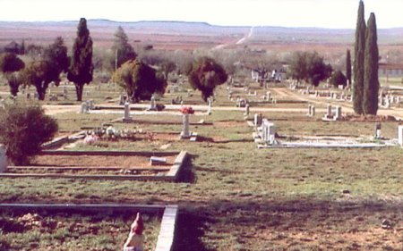
Location: Take I-20 exit South to Loraine, Texas, from Main Street, go South, following road which goes West. Cemetery is about a mile South of Loraine, on the West side of the road.
Transcriptions by
Pat Hudgins and Mary Beth Love
Headstone Photos by
Beth Love Quintela Jose 11/2/31 Age 37 Yrs. Sec. 3
Last Name
First Name
Birth
Death
Section
|
|||
|
Last Updated: |
|||
|
Copyright © 2024 --The TXGenWeb Project - All Rights Reserved
COPYRIGHT NOTICE: All files on this site are
copyrighted by their creator. They may be linked to but may not be reproduced
electronically or otherwise without specific permission from the county host
and/or the contributor. Although public information is not copyrightable, the
format in which it is presented, the notes and comments, etc., are. It is
however, quite permissible to print or save the files to a personal computer for
personal use only.
|